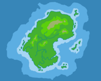
Isla Basaltros
Isla Basaltros is a tropical island in the Lavok Archipelago. It is Dennis Alvarez' childhood home.
Overview
Isla Basaltros is one of the outer islands of the Lavok Archipelago, and an obscure one at that; most people in Dimentiara would probably have a hard time finding it on a map, assuming they'd even heard of it. Tiny and sparsely populated, it's most notable as the archipelago's northernmost island. It's closer in proximity to Solax City in Zaitopia than it is to the archipelago's capital, so there's a lot of economic and cultural exchange between them. For this reason, Isla Basaltros is known colloquially as "Little Zaitopia".
Geographical Features
Basaltros Mountains
Isla Basaltros' origins are volcanic, and Mt. Furia is the island's tallest and most active volcano. It forms the basis of the Basaltros mountain range, which consists of three additional mountains: Mt. Ortega in the west, Mount Rivera in the east, and Mount Castillo between them. They are honeycombed by an extensive cave system that has been carved out over millennia by groundwater and burrowing Wild Kreatures.
Valkala River
The island's primary source of freshwater originates from underground springs in the Basaltros mountains, which flow downhill into the sea and various channels. The Rivera Waterfall in the northeastern part of the river is a beautiful sight to behold. At the base of Rivera Waterfall is Crystal Pond, a large natural pool known for its clear, pristine, refreshingly cool waters. The river starts out clear as glass in the uplands, and as it meanders through the forests the tannins from the decaying vegetation stains the water a more tea-like colour.
Gallos Forest
The island's interior is covered primarily in lush rainforest, nourished by the mineral-rich volcanic soil. Since the island mostly lacks native megafauna (animals over 45kg), the forest is very dense and thick with foliage and vines and has only a few open areas. With little in the way of landmarks and an oppressive green backdrop, it's very easy for inexperienced explorers to become lost and wander around in circles. The easternmost edge closest to Fuego City has been cut down to grow orchards and create farmland.
Fuego Bay
An idyllic lowland which is located on the eastern side of the island, this is where Fuego City is located. Most of the island's population lives in and around this area. Basaltros Beach is the island's primary tourist attraction, with sections of both ordinary white sand and volcanic black sand. Though the black sand is beautiful, beachgoers are encouraged to wear sandals while walking on it; during the day it gets hot as asphalt and can scorch the skin off the soles of your feet.
Barrier Swamp
The Valkala river flows into an extensive mangrove swamp which borders the island's southern edge. The water here is a slow-moving brackish stew of pristine river water and salty sea water, and the ground is muddy and soft. Many unwary travelers have gotten mired and sucked down into the sludge to either drown at high tide or slowly be eaten alive by insects and crabs, a horrible and ignominious fate.
Jaggedel Islands
A cluster of three tiny islands east of Fuego Bay, which are really more like big rocks. They're uninhabited and covered with the same thick foliage as the Gallos Forest, though it's possibly even more dangerous thanks to the rocky, rugged terrain. The Jaggedel Reefs surrounding these islands make boating dangerous, and the region is littered with shipwrecks. Despite the dangers, the wrecks, warm, shallow water and verdant ecosystem make it a great place for scuba diving.
